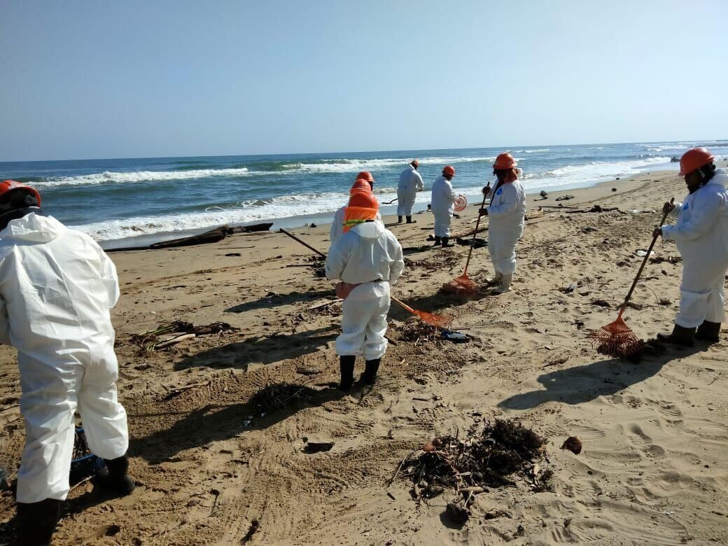
Tourist activity in Ciudad del Carmen, Papantla, Veracruz, Boca del Río, Alvarado, Rancho Playa, and Tuxpan proceeded without issues. Additionally, in the beaches of Pajapan, Veracruz, Profepa personnel reported on April 2nd activities to clean up hydrocarbons, with permanent monitoring in place for possible new arrivals. ASEA is working on the coordination and supervision of cleaning the affected beaches, as well as the comprehensive management of the waste derived from these efforts, establishing specific collection, transfer, and disposal points in various coastal municipalities together with Pemex. Additionally, it implemented a verification deployment during the Holy Week vacation period to preventively monitor beach areas for possible hydrocarbon re-landings, ensuring the continuity of environmental sanitation actions and the proper control of collected contaminating materials. Inspections of vessels are also being carried out in areas such as the Coatzacoalcos anchorage, with the objective of stopping possible illegal discharges, as well as field verification actions and communication with local actors to follow up on the situation in the affected areas. The Interinstitutional Group maintains vigilance, coordination, and permanent monitoring actions, with the objective of guaranteeing accurate information about the situation and strengthening timely attention in the affected zones. Furthermore, Profepa is coordinating with communities and civil society organizations to collect information from each reported affected location. On April 3rd, in Tamaulipas, Profepa personnel conducted surveillance and inspection tours with reports of clean beaches in the south (breakwaters), center (sirens), and north (roundabout) areas of Miramar; a clean coastline in the south area and an unaffected mangrove in Altamira; and cleanup efforts at La Pesca beach. The municipal government of Ciudad Madero maintains several crews to carry out cleaning tasks in the beach area and systematic surveillance tours are carried out at the Rancho Nuevo Turtle Sanctuary. In turn, Conanp conducts permanent surveillance in the nine Natural Protected Areas (NPAs) registered in Veracruz, Tabasco, and Tamaulipas. The Interinstitutional Group (GI), made up of the Secretariats of the Navy (Semar); of Environment and Natural Resources (Semarnat); of Energy (Sener); of Science, Humanities, Technology and Innovation (Secihti); the Agency for Security, Energy and Environment (ASEA); Petróleos Mexicanos (Pemex); the Federal Prosecutor's Office for Environmental Protection (Profepa); the National Commission of Aquaculture and Fisheries (Conapesca), as well as state and municipal authorities, informs the following: The interinstitutional operation for the attention of the presence of hydrocarbons on the Gulf of Mexico coast is maintained, with actions deployed in 48 beaches, of which 32 are already without new landings (7 in Tabasco and 25 in Veracruz), resulting from intensive cleaning, containment, and monitoring work. Through the coordination of 3,365 personnel from the agencies that make up the Interinstitutional Group, tours have been carried out repeatedly on more than 630 kilometers of coastline, as well as maritime and air operations, including reconnaissance flights over the Campeche Sound and the Cantarell complex, in addition to hydrocarbon sampling with its respective chain of custody and vessel inspection. As a result of these actions, a total of 894.2 tons of hydrocarbons have been collected, of which 853.6 tons correspond to beaches and 40.6 tons to the sea, through manual and mechanical work for their proper disposal. For these actions, 25 vessels and boats, 48 vehicles, 9 aircraft, as well as three aerial drones and three submarines have been used, strengthening surveillance, monitoring, and containment tasks. In terms of containment, there are currently 2,000 meters of barrier deployed, and approximately 17,000 meters are in transit to support containment efforts. Complementarily, tours are maintained in various zones, including the Tamaulipas border strip, where approximately 15 kilometers of coastline have been attended to, as well as inspection activities in vessels in areas such as the Coatzacoalcos anchorage to prevent possible discharges. By order of the President of Mexico, Claudia Sheinbaum Pardo, Secihti is coordinating the creation and implementation of a Permanent Gulf of Mexico Observatory, a strategic initiative to monitor climate change, biodiversity, and environmental risks. The Observatory will now operate under an integral model that combines on-site monitoring infrastructure (oceanographic buoys, weather stations, and tide gauges) with satellite technology, digital platforms, and predictive models to generate real-time scientific information. The project articulates with the National Autonomous University of Mexico (UNAM); Autonomous University of Baja California (UABC); and Veracruzana University (UV), among others; as well as with the Center for Scientific Research and Higher Education of Ensenada, Baja California (CICESE); El Colegio de la Frontera Sur (ECOSUR), and the Center for Research in Geospatial Information (Centro GEO) and public agencies to translate scientific knowledge into solutions for the benefit of Mexico. Similarly, in the municipality of Tamiahua, the localities of Agua Dulce, Nuevo Centro, El Coyol, Tantalamos, Palo Blanco, La Puntilla, Barra de Corazones, Zanjita, and Majahual have been visited, as well as in Tampico Alto with the objective of maintaining closeness with the fishing sector, to attend to their needs in a timely manner and strengthen the continuity of fishing activity. Regarding the environmental sector, Profepa and ASEA inspectors went to Playa de Peña Hermosa, located in the municipality of Tatahuicapan, where they verified that Pemex, together with community residents, is removing sargazo, whose presence is already minimal. Its purpose is to link research communities and decision-makers to generate evidence-based public policies and foster community participation. The Permanent Gulf of Mexico Observatory has four strategic objectives that involve monitoring climate change; managing resources for biodiversity care; promoting industrial and environmental security actions; and finally, fostering citizen science, involving communities and students in data collection for research and environmental monitoring. The National Commission of Aquaculture and Fisheries (Conapesca) has visited various localities in the state of Veracruz to directly assist the region's fishermen, providing accompaniment and follow-up on their needs. Among the sites visited are, in the municipality of Alvarado: Antón Lizardo, Salinas, Arbolillo, Buen País, Mata de Uva, El Zapote, Las Barrancas, and El Jiote; in the Catemaco area: Tatahuicapan, Mecayapan, Catemaco, San Andrés Tuxtla, Ángel R. Cabada, and Lerdo de Tejada; in Ciudad Cuauhtémoc: Tampico Alto, Pueblo Viejo, Cabo Rojo, El Tular, Las Chacas, Barra de Tampachiche, and Campo de Bustos; as well as in La Laja, municipality of Ozuluama. Likewise, presence has been maintained in Nautla, Tecolutla, San Rafael, and Vega de Alatorre; in Tuxpan and Cazones de Herrera; and in Veracruz, Boca del Río, El Bayo, Mandinga, La Matoza, Úrsulo Galván, Actopan, and Palma Sola. On April 3rd, personnel conducted seven supervision tours along 37.2 kilometers of coastline without registering affected fauna.